


وصف لـ Marine Ways - Free Nautical Charts
Marine Ways Boating is the ultimate marine navigation and planning application! In this application you will gain access to:
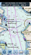
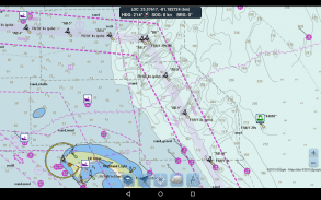
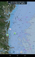
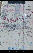
FREE NAVIGATIONAL CHARTS
- United States charts provided by National Oceanic and Atmospheric Administration (NOAA)
- New Zealand charts provided by Land Information New Zealand (LINZ)
Chart types:
- NOAA Electronic Navigational Charts (ENC) (NOAA's newest and most powerful electronic charting product).
- NOAA classic charts (including Day, Red, Dusk, Night, and Gray versions).
- LINZ charts (available in Day, Dusk, and Night versions only currently)
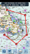
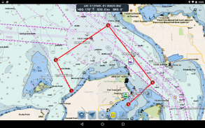
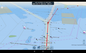
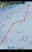
ROUTE PLANNING TOOLS
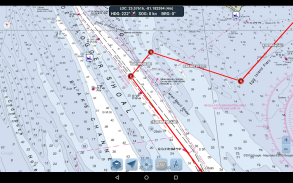
-Route Plotting. Tap and hold on the map for one second to plot your waypoints. To form a route, continue to tap and hold on the map in different areas. Distance and bearing are conveniently calculated and displayed for each leg as you add, adjust, or remove waypoints.
-Travel Mode. Automatically centers the map on your current position as you move. Use travel mode to see how closely you are following your plotted route in real time!
-Route Leg Summary. A convenient view containing detailed information of each leg you have plotted, including start and end coordinates, distance, and bearing.
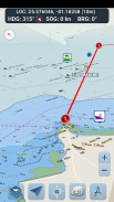
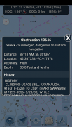
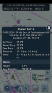
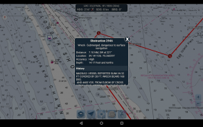
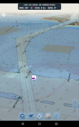
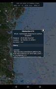
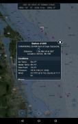
BUOY REPORTS AND OBSTRUCTION INFORMATION
Markers for buoys and obstructions are conveniently plotted in their actual location on the map! Just click on the marker to view their information!
- Buoy Reports: Get complete current conditions and wave reports for fixed and drifting buoys.
- Obstructions: Get location and history information about potentially dangerous, submerged hazards including rocks and sunken vessels.
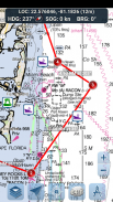
NAVIGATION DASHBOARD
The navigational dashboard shows various real-time information including:
- Current location (latitude and longitude, with accuracy range)
- Current Heading (includes a small directional compass as well!)
- Current Speed Over Ground
- Current Bearing
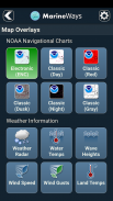
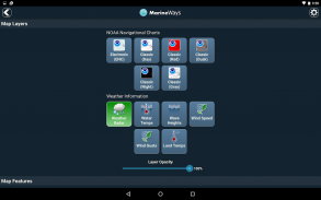
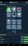
MARINE MAP OVERLAYS
Toggle various marine overlay data right onto the map to get a better idea of the current boating conditions!
Overlays include:
- Water Surface Temperature (Global)
- Wind Speeds (US only)
- Wind Gusts (US only)
- Wave Heights (US only)
LOCATION SHARING OVER WATER / VIEW OTHER BOATS
- Display your last known location, speed, bearing, and boat name on the map for other Marine Ways boaters to view.
- View the last known location, speed, bearing, and boat name of other Marine Ways boaters, as well as their distance and bearing from your location.
- Location sharing is turned off by default. When you are ready to share, toggle it on within general settings. To continuously update your location on the map, keep the app opened and focused. The app currently does not update your location in the background.
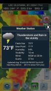
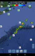
WEATHER INFORMATION
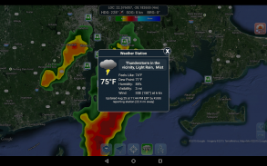
- Weather Precipitation Radar (US & Hawaii only). Detects any rain and snow in the area.
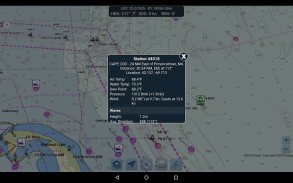
- Weather Station. Reports the nearest observation station data. Current temperature, humidity, weather conditions, wind, and more! Station observation data is available globally.
- Weather Alerts. Weather station also reports any active weather alerts issued by the National Weather Service such as severe thunderstorm warnings or hurricane warnings. Weather alert information is available for US, Alaska and Hawaii.
- Land Surface Temperature overlay. Shows the current surface temperature on land (US only).
Before using this application, please read and agree to the following terms of use / service and privacy policy:
Terms of Use / Service: http://www.marineways.com/appterms
Privacy policy: http://www.marineways.com/appprivacy
Navigational Charts Disclaimer from NOAA:
NOAA ENC Online is not certified for navigation. Screen captures of the ENCs displayed here do NOT fulfill chart carriage requirements for regulated commercial vessels under Titles 33 and 46 of the Code of Federal Regulations.
Enjoy the app! Marine Ways is also available on the web at http://www.marineways.com
Marine Mays Boating هو تطبيق الملاحة والتخطيط البحري النهائي! في هذا التطبيق سوف تتمكن من الوصول إلى:
المخططات المجانية للملاحة
- مخططات الولايات المتحدة المقدمة من الإدارة الوطنية للمحيطات والغلاف الجوي (NOAA)
- الخرائط النيوزيلندية التي قدمتها Land Information New Zealand (LINZ)
أنواع الرسوم البيانية:
- NOAA الخرائط الملاحية الإلكترونية (ENC) (أحدث وأحدث الرسوم البيانية الإلكترونية NOAA المنتج).
- الرسوم البيانية NOAA الكلاسيكية (بما في ذلك الإصدارات Day ، و Red ، و Dusk ، و Night ، و Gray).
- مخططات LINZ (متوفرة حاليًا في إصدارات اليوم والغسق والليل)
أدوات تخطيط الطريق
-Route بالتآمر. انقر مع الاستمرار على الخريطة لمدة ثانية لتخطيط نقاط الطريق. لتشكيل مسار ، استمر في النقر مع الاستمرار على الخريطة في مناطق مختلفة. يتم حساب المسافة والتحمل بشكل ملائم لكل ساق أثناء إضافة أو ضبط أو إزالة نقاط الطريق.
وضع السفر. يقوم تلقائيًا بتوسيط الخريطة على موقعك الحالي أثناء تحركك. استخدم وضع السفر لمعرفة مدى قربك من اتباع الطريق المرسوم في الوقت الحقيقي!
-Route الساق موجز. طريقة عرض مريحة تحتوي على معلومات مفصلة عن كل ساق رسمتها ، بما في ذلك إحداثيات البداية والنهاية والمسافة والحمل.
تقارير BUOY ومعلومات التعقب
تم تصميم علامات العوامات والعوائق بشكل ملائم في موقعها الفعلي على الخريطة! ما عليك سوى النقر على العلامة لعرض معلوماتها!
- تقارير العوامات: احصل على الشروط الحالية الكاملة وتقارير الموجات عن العوامات الثابتة والمنجرفة.
- العوائق: الحصول على معلومات عن الموقع والتاريخ حول الأخطار التي يحتمل أن تكون خطرة ومغمورة بما في ذلك الصخور والأوعية الغارقة.
ملاحة DASHBOARD
تعرض لوحة المعلومات الملاحية العديد من المعلومات في الوقت الفعلي بما في ذلك:
- الموقع الحالي (خطوط الطول والعرض ، بمدى الدقة)
- العنوان الحالي (يتضمن بوصلة اتجاهية صغيرة أيضًا!)
- السرعة الحالية على الأرض
- وإذ تضع الحالي
مارين MAP MAPERLAYS
تبديل بيانات تراكب البحرية المختلفة مباشرة على الخريطة للحصول على فكرة أفضل عن ظروف ركوب القوارب الحالية!
تشمل التراكبات ما يلي:
- درجة حرارة سطح الماء (عالمي)
- سرعات الرياح (الولايات المتحدة فقط)
- هبوب الرياح (الولايات المتحدة فقط)
- ويف هايتس (الولايات المتحدة فقط)
تقاسم الموقع أكثر من الماء / عرض القوارب الأخرى
- عرض آخر موقع معروف لديك ، والسرعة ، واضعة ، واسم القارب على الخريطة لغيرها من السفن الملاحية البحرية لعرض.
- عرض آخر موقع معروف ، والسرعة ، واضعة ، واسم القارب من المارين البحرية الطرق الأخرى ، فضلا عن المسافة والتحمل من موقعك.
- يتم إيقاف تشغيل مشاركة الموقع افتراضيًا. عندما تكون مستعدًا للمشاركة ، يمكنك تبديلها ضمن الإعدادات العامة. لتحديث موقعك باستمرار على الخريطة ، حافظ على فتح التطبيق وتركيزه. لا يقوم التطبيق حاليًا بتحديث موقعك في الخلفية.
معلومات الطقس
- رادار هطول الأمطار الطقس (الولايات المتحدة وهاواي فقط). بالكشف عن أي المطر والثلوج في المنطقة.
- محطة الطقس. تقارير أقرب بيانات محطة المراقبة. درجة الحرارة الحالية والرطوبة والظروف الجوية والرياح ، وأكثر! بيانات مراقبة المحطة متاحة على مستوى العالم.
- تنبيهات الطقس. كما تشير محطة الطقس إلى أي تنبيهات مناخية ناشئة تصدرها دائرة الأرصاد الجوية الوطنية مثل التحذيرات العاصفة الرعدية أو التحذيرات من الأعاصير. تتوفر معلومات تنبيه الطقس في الولايات المتحدة وألاسكا وهاواي.
- تراكب درجة حرارة سطح الأرض. يظهر درجة حرارة السطح الحالية على الأرض (الولايات المتحدة فقط).
قبل استخدام هذا التطبيق ، يرجى قراءة شروط الاستخدام / الخدمة وسياسة الخصوصية التالية والموافقة عليها:
شروط الاستخدام / الخدمة: http://www.marineways.com/appterms
سياسة الخصوصية: http://www.marineways.com/appprivacy
الخرائط الملاحية تنويه من NOAA:
NOAA ENC Online غير معتمد للتنقل. إن لقطات الشاشة الخاصة بـ ENC المعروضة هنا لا تلبي متطلبات النقل البيانية للسفن التجارية الخاضعة للوائح تحت العنوانين 33 و 46 من قانون اللوائح الفيدرالية.
استمتع التطبيق! الطرق البحرية متاحة أيضا على شبكة الإنترنت في http://www.marineways.com
Marine Ways - Free Nautical Charts - إصدار 1.33
(23-09-2023)Marine Ways - Free Nautical Charts - معلومات APK
نُسخة APK: 1.33الحزمة: com.marineways.androidتطبيقات من الفئة نفسها
قد يعجبك أيضًا...


